Free D-Day Map PDF - the Normandy Landing Sites to Visit
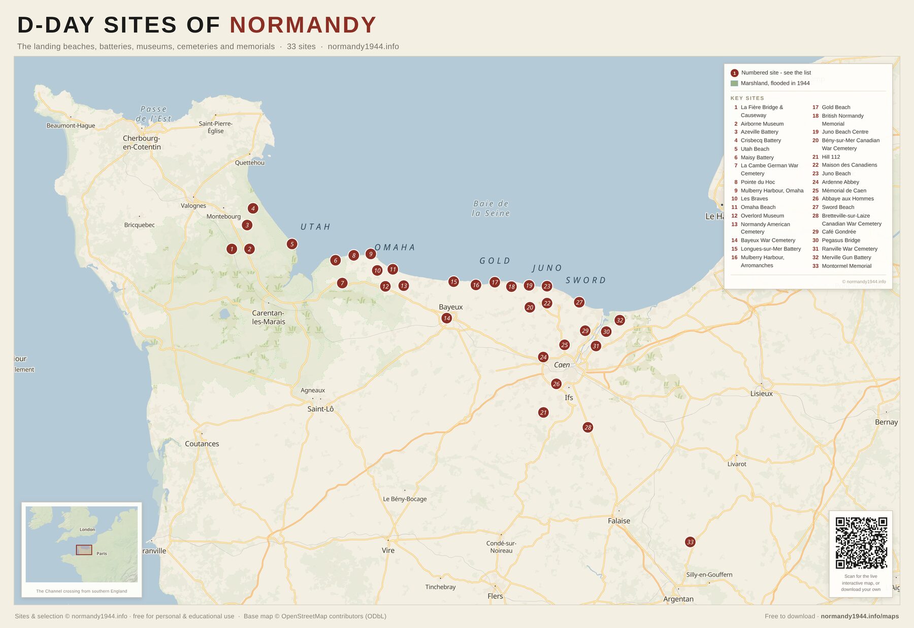
Download a free, printable PDF map of the D-Day landing sites in Normandy. It marks and numbers the key sites along the invasion coast - Utah and Omaha beaches, Pointe du Hoc, the Longues-sur-Mer battery, the Mulberry harbour at Arromanches, the Normandy American Cemetery and Pegasus Bridge - on a clear present-day map running from the Cotentin peninsula east to the Orne. Free for personal and educational use.
A3 · PDF · 616 KB
- The invasion coast on one A3 sheet, from the Cotentin peninsula east to the Orne
- Every site numbered west to east and named in the key panel
- The marshland the Germans flooded in 1944, drawn as marsh rather than as water
- Print-ready A3 that still reads clearly printed on A4
Licence
Free for personal and educational use - please keep the attribution intact. Not for resale or commercial redistribution. Sites and selection © normandy1944.info; base map data © OpenStreetMap contributors (ODbL).
What is on this map
All 33 sites are numbered on the sheet, west to east along the coast. Open any one for its opening hours, prices and how to find it.
- 1 La Fière Bridge & Causeway
- 2 Airborne Museum
- 3 Azeville Battery
- 4 Crisbecq Battery
- 5 Utah Beach
- 6 Maisy Battery
- 7 La Cambe German War Cemetery
- 8 Pointe du Hoc
- 9 Mulberry Harbour, Omaha
- 10 Les Braves
- 11 Omaha Beach
- 12 Overlord Museum
- 13 Normandy American Cemetery
- 14 Bayeux War Cemetery
- 15 Longues-sur-Mer Battery
- 16 Mulberry Harbour, Arromanches
- 17 Gold Beach
- 18 British Normandy Memorial
- 19 Juno Beach Centre
- 20 Bény-sur-Mer Canadian War Cemetery
- 21 Hill 112
- 22 Maison des Canadiens
- 23 Juno Beach
- 24 Ardenne Abbey
- 25 Mémorial de Caen
- 26 Abbaye aux Hommes
- 27 Sword Beach
- 28 Bretteville-sur-Laize Canadian War Cemetery
- 29 Café Gondrée
- 30 Pegasus Bridge
- 31 Ranville War Cemetery
- 32 Merville Gun Battery
- 33 Montormel Memorial
Keep exploring
Frequently asked questions
Is the D-Day map really free to download?
Yes. The PDF is free for personal and educational use - download it, print it, share the link. There is no sign-up and we never ask for an email address. We only ask that you keep the normandy1944.info attribution on the sheet.
What size is the PDF, and can I print it at home?
It is laid out at A3, which is the size to ask for at a print shop. It also prints legibly on A4 at home if you choose "fit to page". The file is a compact PDF of about 616 KB.
Which sites are marked on the map?
The 33 key sites along the invasion coast, numbered west to east and named in the key panel: the five landing beaches, the German batteries, the main museums, the war cemeteries and the memorials. The full set of 87 sites, including the liberation villages inland, is on the website.
Can I use the map for a school trip or in class?
Yes - that is exactly what educational use means here. Print as many copies as your group needs. Please keep the attribution on the sheet, and do not resell it or fold it into something you charge for.
Does the map work without a phone signal?
That is what it is for. Coverage along the coast and in the bocage is patchy, and a printed sheet needs no battery. Print it before you travel, and use the interactive map for planning and for opening hours.