Mulberry Harbour, Arromanches
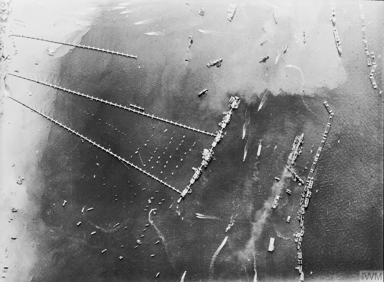
To supply the invasion before a port could be captured, the Allies towed two prefabricated harbours across the Channel. The remains of Mulberry B - vast concrete caissons forming the breakwater - still lie in the bay off Arromanches and can be seen from the seafront at low tide, a striking monument to wartime engineering.
Stand on the seafront at Arromanches and look out to sea, and the horizon is broken by a line of dark, blocky shapes riding the swell. They are not rocks. They are the concrete remains of a harbour the size of Dover, built in England, towed across the Channel in pieces, and assembled off this small resort town in a matter of days. The planners knew the invasion would fail if it could not be supplied, and that the heavily defended Channel ports could not be taken quickly or intact. Their answer was to bring the port with them.
Building a harbour in a fortnight
Arromanches was chosen with care. It sits in a shallow bay screened by rocky reefs and low cliffs, offering a measure of natural shelter, and it lay behind the British Gold Beach sector. The town itself was captured on the evening of D-Day, and it was deliberately spared heavy bombardment so that the ground behind the beach could serve as a supply hub.
Two Mulberry harbours were planned, one for the Americans at Omaha and one, Mulberry B, here. The first great concrete caisson was sunk at dawn on 8 June 1944, and within a week more than a hundred had followed, forming a breakwater arc several miles long between Tracy-sur-Mer and Asnelles. These caissons, codenamed Phoenix, came in six sizes and weighed thousands of tons apiece. Behind them, older merchant ships and warships were scuttled bow to stern as blockships, the "Gooseberries," and floating steel breakwaters were moored further out. Inside this calmed water, floating roadways carried lorries from pier heads that rose and fell with the tide directly onto the beach.
The engineer and the storm
The floating roadways, codenamed Whale, were the harbour's masterstroke, and they were the work of a young British civil engineer, Allan Beckett. His flexible bridge spans, each around eighty feet long and resting on pontoon floats called Beetles, could twist and flex with the waves rather than snap. To hold the whole structure against the tide he designed a light anchor, tested in the mud of a Thames yacht club, that weighed a few hundred kilograms yet could grip with the force of tens of tons. So many were driven into the seabed that most were never recovered.
Their design was vindicated within a fortnight. From 19 June a severe summer gale battered the coast for three days and destroyed the American Mulberry at Omaha outright. Mulberry B, better sheltered and more robustly built, was damaged but survived, and was patched up using parts salvaged from its ruined twin. Renamed Port Winston, it was meant to last three months and instead worked for the better part of a year, landing in that time some two and a half million men, half a million vehicles and around four million tons of supplies.
What to see today
The town wraps around the harbour it created, and the D-Day Museum on the seafront is the natural starting point, with working models that show how the parts fitted together. But the real exhibit is the bay itself. Check the tide before you come: at low water the sea retreats to reveal caissons and roadway sections stranded on the sand, and you can walk out to touch concrete cast eighty years ago. Look near the museum for a preserved Whale bridge span and a memorial to Allan Beckett, whose name most visitors never learn. For the fullest sense of scale, climb the path to the cliff-top viewpoint east of town: from there the whole grey arc of Port Winston reveals itself at once, a five-mile ghost of the harbour that kept the liberation of Europe supplied.
Practical notes
Arromanches is reached by the D514 coast road, which drops through a fold in the cliffs into the town. There are car parks on the high ground either side of the town as well as behind the seafront, and the seafront spaces fill early in season, so parking up on the cliff and walking down is often the easier choice. The seafront and the beach are open access and free; the museum is ticketed.
Allow around two hours: an hour on the front and the sand, an hour for the museum and the viewpoint. Time your arrival for low water if you can, because that is when the caissons and roadway sections can be reached on foot.
The promenade is level and paved and the beach at low tide is firm flat sand, so the town itself works well with a wheelchair or a pushchair. The climb east to the cliff-top viewpoint is another matter: steep, partly stepped and unsurfaced, though it can also be reached by road. Longues-sur-Mer Battery is a short drive west and pairs naturally with a morning here, while Bayeux makes the obvious base inland.