Mulberry Harbour, Omaha
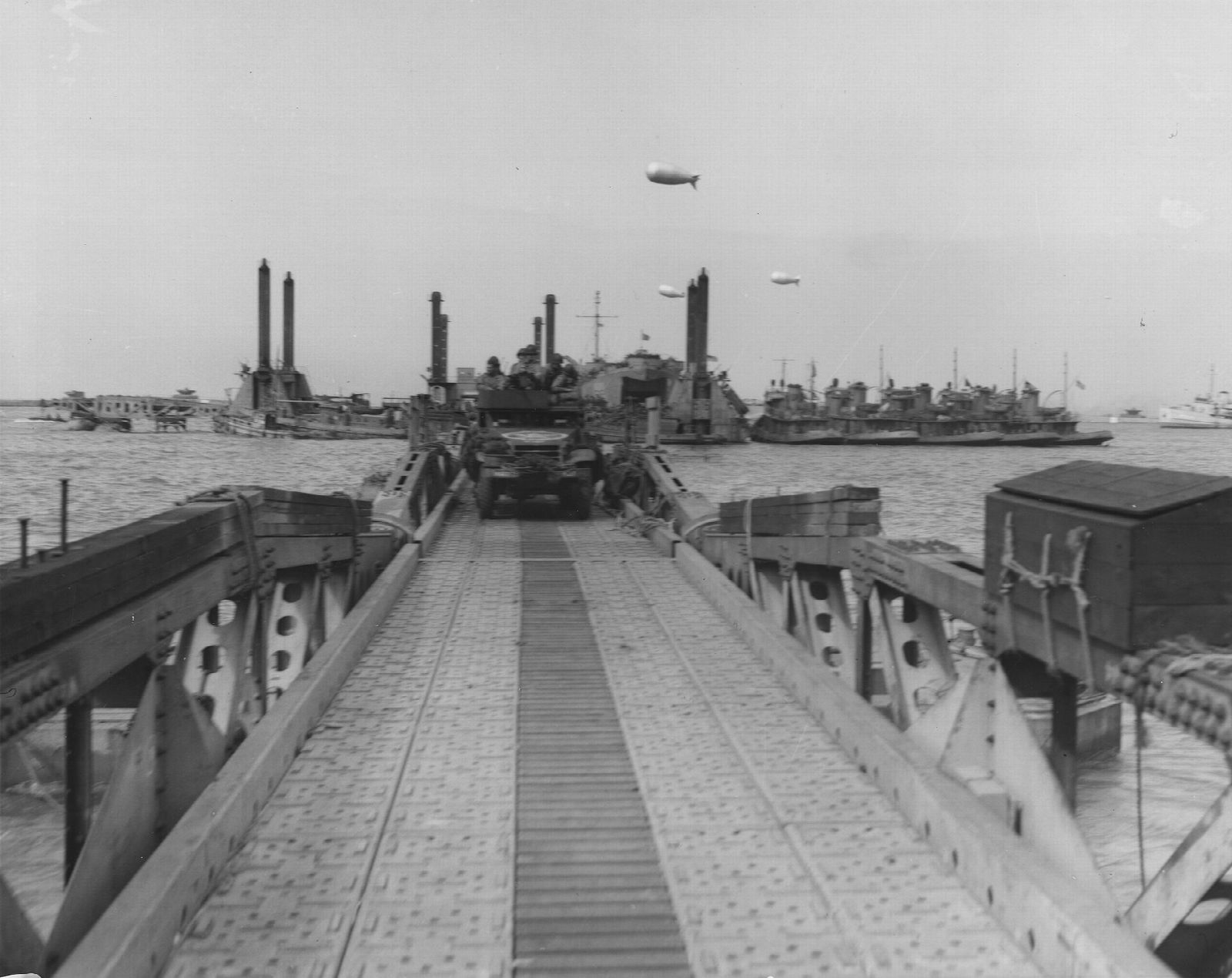
Two prefabricated harbours were towed across the Channel in June 1944. This was the other one. Mulberry A was assembled off Omaha, worked for barely a week, and was destroyed by the great storm of 19 to 22 June. Its concrete caissons still lie scattered offshore between Vierville-sur-Mer and Colleville, visible from the seafront at low tide and best understood from the interpretation panel above the Vierville draw.
Everyone who comes to Normandy hears about the Mulberry harbour, and almost everyone means the one at Arromanches, where the caissons still stand in a great arc you can photograph from the cliff. There were two. The second was built here, off Omaha Beach, and it is the reason for the pale fragments scattered across the water between Vierville-sur-Mer and Colleville. Mulberry A is the harbour that failed, and its story is the more instructive of the two.
Why build a harbour at all
The invasion planners faced a problem with no good answer. An army ashore needs a port, and every port on the French coast was fortified, mined and certain to be demolished before it could be captured. The raid on Dieppe in 1942 had shown what assaulting a defended harbour cost. So the decision was made to bring the harbour with them.
The components were built in Britain and towed over in pieces: hollow concrete caissons called Phoenixes, sunk in line to form a breakwater; old merchant ships and warships scuttled bow to stern as a first shelter, known as Gooseberries; floating steel roadways called Whales, running from pierheads that rose and fell on legs planted in the seabed. Assembly off this coast began within a day or two of the landings.
Eight days
Mulberry A took shape off Saint-Laurent-sur-Mer and was working by the middle of June, with vehicles driving off the pierheads and along the floating roadway to the sand. Photographs from 16 June show the thing functioning exactly as designed, which is worth dwelling on, because it did not last.
On 19 June a north-easterly gale set in and blew for three days. It was the worst Channel storm in decades, and it came from precisely the direction the breakwaters were weakest against. The Whale roadways broke up, caissons shifted and cracked, and craft were driven ashore in numbers. By 22 June Mulberry A was wreckage. It was written off, and what could be salvaged was taken east to strengthen Arromanches, which had been better sheltered and survived.
What happened next is the part usually left out. Supplies kept coming ashore at Omaha anyway, run straight onto the beach from landing ships at low tide and driven off as the water fell. Over the following months this beach moved a great deal of cargo without a harbour at all. The engineering that failed here was magnificent, and it turned out not to have been indispensable.
What is actually out there
Do not expect Arromanches. There is no arc. What survives is a scatter of broken caissons and blockship remains spread over several kilometres, some of it well offshore, much of it covered at high water. Plot it on a chart and it makes no clean shape, because the storm and forty years of salvage and sea left none.
The best vantage point is the seafront at the Vierville draw, where an interpretation panel sets out the harbour's layout against the view. Come at low water on a clear day and you can pick out dark shapes offshore. Come at high water and you will see nothing at all, which is honest enough: this is a site you largely have to imagine, and the 1944 photographs do more work than the horizon does.
Practical notes
The panel and the viewpoint are on the seafront at Vierville-sur-Mer, where the D517 drops to the beach. There is parking at the bottom of the road and the promenade is a few steps away. No ticket, no gate, open at all hours.
Allow twenty minutes, or longer if the tide is out and you want to walk the sand. The promenade is level and firm and takes a wheelchair comfortably; the beach below it does not. There is no shelter and the wind here is constant.
Pair it with the sculpture Les Braves and the memorials along the beach to the east, and with the Normandy American Cemetery on the bluff above Colleville-sur-Mer. If you want the contrast that makes this site make sense, drive east to Arromanches afterwards and look at the harbour that survived.